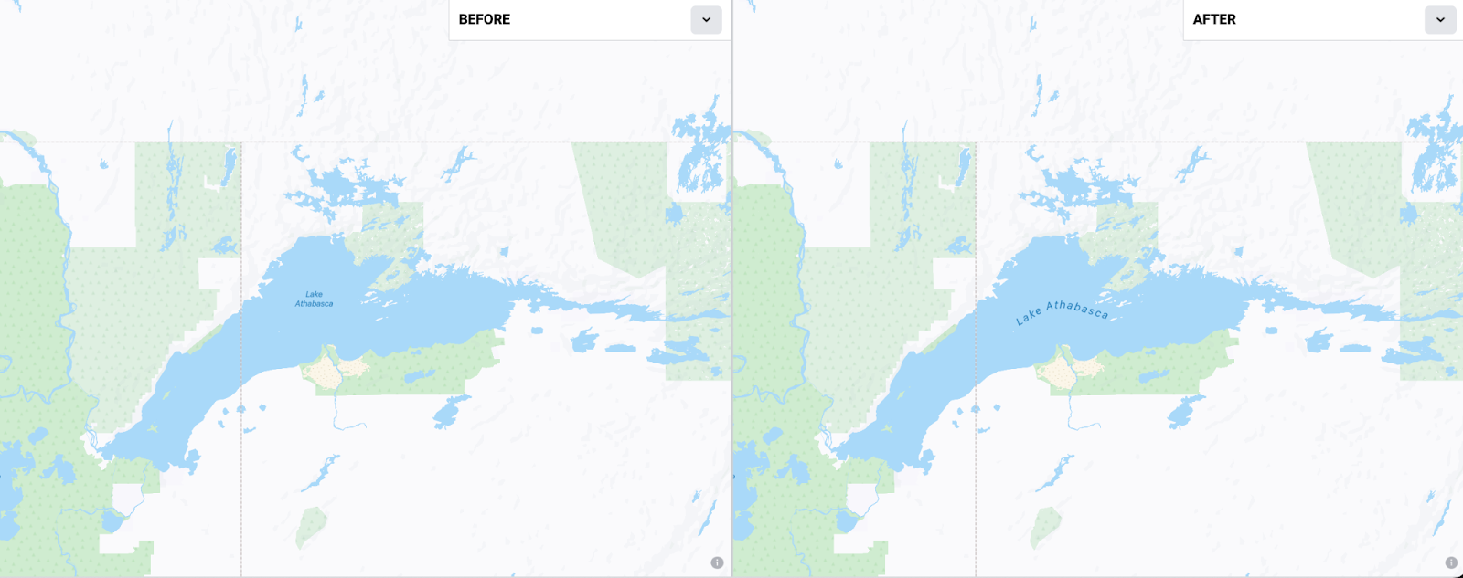
 Example of curved label placement for Lake Athabasca, CA.
Home / Data: Planet, Coastlines, Buildings, Admins, Roads / Attribution
Mar 20th, 2023
Starting in v1.24, the Daylight Map Distribution will include a new dataset consisting of 1905 cartographic label features derived from the largest interior water bodies in OpenStreetMap. These curvilinear features create a wonderful “hand drawn” effect for labels when making maps with the Daylight Map Distribution.
The Display Maps team at Meta serves beautiful maps to a variety of applications like Facebook, Instagram, WhatsApp, and many others using data from Daylight Map Distribution. A few years ago, our cartographers created hand drawn line labels for 120 of the worlds largest oceans and bays. While this custom touch brings a unique feature to our maps, its not something we could scale to thousands of features. For the majority of our area based labels, we use a similar pole of inaccessibility method to derive points at scale in the best possible place. While this is generally a great solution, it can be restrictive or non-representative of the area/feature it embodies.
To increase dynamic labeling, we recently created a process that derives curved centerlines from polygonal OSM water geometries. The new labels provide better representation of elongated water bodies by providing a best ‘fit’ of the geometry, taking into consideration the directionality, shape, and orientation of the feature itself.
Example of curved label placement for Lake Athabasca, CA.
 Major cities like Detroit (center), Geneva (right), and Jönköping (left) now have water labels – seen here between z8 to 14 with iPhone14 device view.
These linear label features add a third component to the map: directionality. Rather than a static point, the labels often provide added contextual information by following the shape and orientation of the feature it represents. To further illustrate the idea of directionality, we measured the major angle of orientation from start-to-end points of the generated line labels.
 Example of added directionality from dynamic labeling.
Overall, we see that the majority of inland water features span horizontally. About 21% of all lake features and 16% of all reservoirs in the sample were categorized with East to West heading and vice versa, whereas only 6-8% of all waters spanned vertically. Some differences in distribution for cumulative length were seen where greater numbers of large water bodies are more diagonally oriented e.g. NNW and SSW directions, respectively, as seen for Lake Winnipeg example above.
 Windrose diagram showing directionality of generated label lines based on class for cumulative length (left) and total feature count (right).
Starting with the 2700 largest water features, 70% met the shape requirements determined by the major-minor axis ratio greater than 0.6 – including 1474 lakes, 431 reservoirs, lagoons, and ponds. Note that certain water features with rounder geometries such as Lake Victoria and Lake Tahoe did not fit the criteria, however exceptions were made for borderline cases such as Lake Huron, Lake Mead, and Lake Nubia. Our general workflow for deriving the linear features from elongated inland water polygons is: (1) generate buffer (2) retrieve exterior bounds + simplify (3) create Voronoi diagram (4) identify longest route (5) smooth curved line for ‘best fit’.
After conducting the first iteration of QA checks, general improvements were made to the methodology to account for complex water geometries. When compared to the initial version, 78% of generated centerlines saw an increase in length by an average of 7 km (see below image). These instances of increased length were generally found for water geometries that had narrowing channels and/or multiple extensions to tributaries. Overall, the latest version has a moderate correlation (r=0.58; p < 0.005) between generated label length and its associated feature size, identified via the Pearson’s Coefficient.
 Top increases in generated line distance. Before - dashed black After - dashed red
This new dataset is kept in sync with changes in OSM through our Daylight process and will continue to be updated with each release going forward. We plan on lowering the acceptable area threshold to include more water features over the first half of 2023. We hope this new product is useful to Daylight users, and would welcome and encourage feedback from the community. You can preview these new labels in action across all map surfaces at Meta, like this Mapillary web app.
This dataset is available in the latest Daylight release on S3 at release/v1.24/water-label-centerlines-v1.24.geojsonseq
If you have any questions about this data distribution, we have created a #daylightdistro_feedback Slack channel in OSM US. Members of the team will be there periodically to answer questions. You can also email the team at osm@fb.com.